Among numerous findings throughout the years, researchers around the globe have stumbled upon certain discoveries that should have never been made. Some of these discoveries directly contradict the beliefs and ‘tales’ set forth by mainstream scholars about mankind, its origins and ancient civilizations that inhabited our planet in the distant past.
It has become a popular belief that ancient civilizations across the globe were in fact much more advanced than what mainstream researchers are crediting them for. Numerous maps discovered in the past are clear indications that the story told today by scholars is incomplete, and there are numerous missing links in our history. These ‘missing links’ are being put together by these incredible ancient maps that prove mankind inhabited our planet much longer than what mainstream scholars believe.
However, the existence of these incredible maps proves that in the distant past, ancient explorers had an extremely well-developed cartography system comparable in precision with the one we have today. The maps are also evidence that ancient mankind knew the exact shape and size of the Earth, contrary to popular beliefs, and used spherical trigonometry, and precise and elaborate mathematical calculations, as if thousands of years ago, an unknown civilization undertook a global-scale project of mapping te entire planet like no one has ever done before.

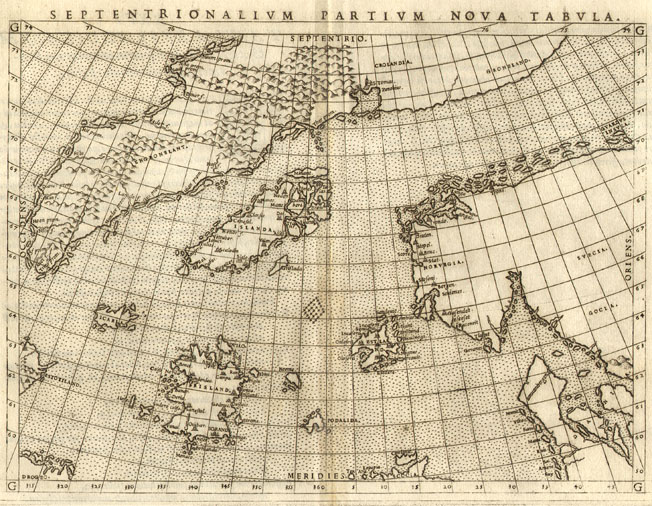
A reproduction of the Zeno map from a 1793 book The Zeno map is a map of the North Atlantic first published in 1558 in Venice by Nicolo Zeno, a descendant of Nicolo Zeno, of the Zeno brothers. The younger Zeno published the map, along with a series of letters, claiming he had discovered them in a storeroom in his family’s home in Venice. According to Zeno, the map and letters date from around the year 1400 and purportedly describe a long voyage made by the Zeno brothers in the 1390s under the direction of a prince named Zichmni. Supporters of the Henry Sinclair legend suggest that Zichmini is a mistranscription of d’Orkney. The voyage supposedly traversed the North Atlantic and, according to some interpretations, reached North America.
One of the most intriguing maps is the Zeno Map. Published around 1380, the enigmatic maps accurately depicts the coasts of modern-day countries such as Norway, Sweden, Denmark, Germany, and Scotland. Mysteriously, this ancient map also depicts the EXACT latitude and longitude of a number of islands on our planet. This is a huge enigma since the device necessary to measure the longitude, the chronometer, was not invented until 1765. If this isn’t mysterious enough, the Zeno map also depicts Greenland free of glaciers, meaning that somehow, someone charted it prior to the Ice Age.
Zeno map: Phantom islands
Estotiland
“Estotiland” appears on the Zeno map, ostensibly on the western side of the Atlantic Ocean in the location of Labrador. Estotiland is listed along with Eden and Arcadia under the heading ‘utopia, paradise, heaven, heaven on earth’ in Roget’s International Thesaurus. It is one of the sources for the Russian “Estoty”, featured in Vladimir Nabokov’s Ada.
Frisland
“Frisland” appeared on virtually all maps of the North Atlantic from the 1560s through to the 1660s. It is not to be confused with the similarly named Friesland in the Netherlands. It originally referred to Iceland, but after the Zeno Map placed it as an entirely separate island south of Iceland, it appeared that way on maps for the next 100 years.
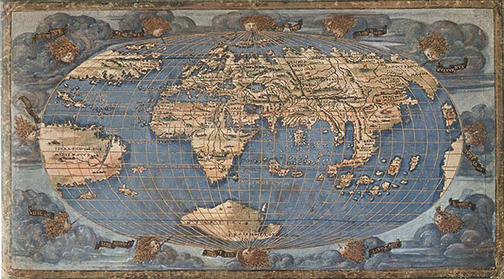
The Camerio map. Created in 1502, this map does not depict unusual features as other maps do but it has one very strange detail. The Camerio map uses a spherical grid, even though people in the middle ages still believed our planet was in fact… flat.
Another mind boggling map is without a doubt the Iehudi Ibn ben Zara map. Created in 1487, the map displays remnants of glaciers in Britain, but also extremely detailed depictions of islands in the Mediterranean and Aegean seas. Today, these islands still exist, but due to rising water levels, these are now underwater.
The Hadji Ahmed map, published in 1559, shows incredibly accurate delineations of the western coast of Northern America and Antarctica. What is even more incredible is the fact that this ancient map shows a land bridge connection Siberia and Alaska, indicating it originated from a time when the bridge was still present.
The Bauche Map of 1737

Phillip Bauche was a French geographer of the 18th century who also drew a map that clearly shows Antarctica except that Bauche’s map shows Antarctica two separate land masses, with detailed shorelines (fig.3). For many years the map was generally considered to be wrong because when Antarctica was discovered it actually looked nothing what Bauche had drawn. Then in 1958 a seismic survey of Antarctica was carried out which surprisingly showed that Antarctica was indeed two archipelago islands covered by a thick layer of ice that made it appear as only one land mass and not only that, but that the general topography of the lands beneath the ice matches the drawings on the Bauche map in every detail. So how on earth this can be in any way possible? This map means that Bauche was in possession of a correct map showing Antarctica 100 years before it was discovered and not only that, but without any ice on it. Antarctica has not been in an ice free condition for a minimum of at least 10,000 years and many scientists believe that the period of time to be more like several million years.
The Orontius Finaeus Map of 1531
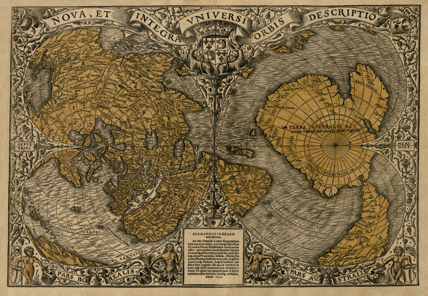
The Orontius Finaeus map was found in 1960 by Charles Hapgood and it too, apparently shows the continent of Antarctica along with the accurate outlines of Antarctic rivers that are now covered by thick glaciers. The map was found in the Library of Congress in Washington DC where it had been sitting unstudied for a great many years. In the map the continent and coastline is shown to be ice free and, like the Piri Reis map, it too shows an accurate depiction of the Ross Sea which today is totally hidden beneath a floating ice shelf several hundred meters thick. Studies of actual core samples taken from the Antarctic ice shelf have also clearly revealed numerous layers of strata in the ice showing that the area has indeed gone through several periods of dramatic environmental change. Some sedimentary deposits that were found in the samples were from sea water that had flowed into the area and were even actually datable. The tests show that the sediments were deposited sometime around 4000 years ago which indicates that the Ross Sea would have had to have been flowing and free from ice at the time for the deposits to have occurred.
The Mercator Map of 1538
And even yet another intriguing map is one drawn in 1538 by Mercator, another highly respected cartographer who lived in the 16th century. His works are quite famous and you can still buy a Mercator atlas in shops today. Mercator was known to periodically update is works and produce a new, more definitive world atlas as more shores became charted and more accurate charts become available to him. In doing such an update, his 1538 world map (fig.5) was replaced by a new one in 1569. However we now know that not only was his 1538 map far more accurate than the latter one but what proved to be even more amazing was that it also contained correct measurements of longitude. To put all this mention of longitude into some sort of perspective for you: Longitude is the distance in degrees east or west of the Prime Meridian. Due to the Earths rotation, it is far harder to calculate longitude than it is latitude, which can be measured by using the stars or the sun for
observation. To calculate Longitude, requires an equation of ‘distance = speed x time’ and, most importantly, an accurate clock. Discovering longitude was once described as “greatest of all naval problems” and in the 1700’s an actual Board of Longitude was set up in England to solve the issue. In 1714, Sir Isaac Newton appeared before the board and explained that the real problem was that “a watch required for such accuracy has not yet been invented”. The Queen then offered a prize of 20,000 pounds to any man who might build such a device and finally, in 1761, a man by the name of Harrison claimed the prize and put forth his prototype chronometer which then “ushered in a new era of sea travel” for the world.
During the 19th century maps then began being updated with the correct degrees of longitude. However Mercator’s map of 1538 was marked with correct longitude a full 223 years before it was discovered. Where was he able to gain that information from? It is obvious that Mercator himself had no real knowledge of longitude at the time and must have borrowed or been given the information from another source because he then updated his subsequent maps incorrectly with
what was considered to be more recent and therefore, supposedly more reliable information. These maps constitute some extremely significant evidence indeed, for if ancient man had never circumnavigated the globe or possessed any knowledge of longitude then how can any of these maps exist?
Created in 1502, the Harry King Chart displays northern Siberian rivers emptying into the Arctic ocean which is now under ice. Interestingly, it also depicts glacial remains in the Baltic countries and accurately depicts the ancient Suez Canal. This incredible map also depicts what today are huge islands in Southeastern parts of Asia, but joined together by land, indicating that geologically speaking, the maps were created when the Earth looked much differently.
The Map of the North by Ptolemy depicts glacial sheets moving across south-central Greenland. It also depicts glaciers retreating from modern-day Germany (north) and parts of southern Sweden. Another map indicating a different time on Earth.
Another interesting map is the King Jaime World Chart. It was created in 1502, and accurately depicts parts of the Sahara Desert displaying it much differently than it is today: with fertile land, huge lakes rivers and what appear to be ancient cities. In fact, Sahara was, in the distant past, a fertile land filled with animal life and forests.
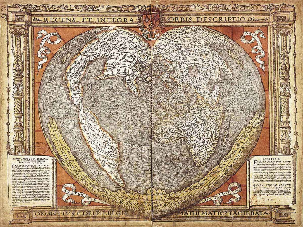
The Oronce Finé World Map created in 1534, is an early cordiform chart which displays features of Antarctica when the continent was not covered by Ice. While it is yet another map which shows the continent before it was officially ‘found’, the chart also shows continent rivers, valleys, and coastlines while also depicting the approximate location of what is the South Pole today.
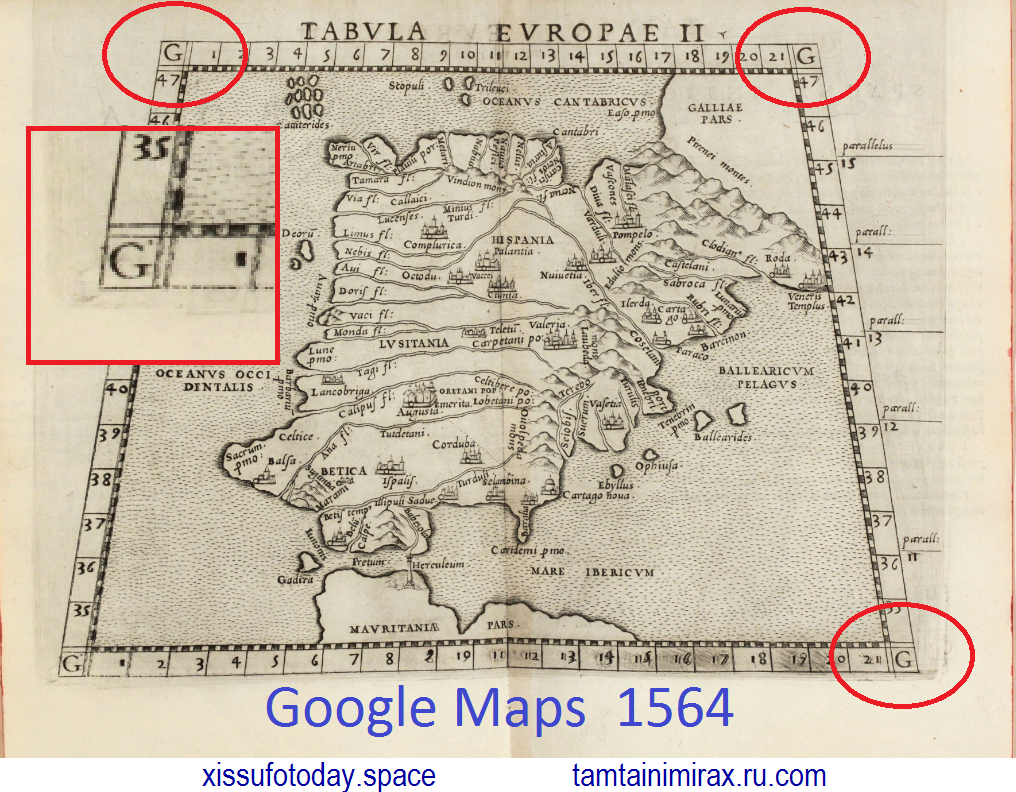
1564: Ptolemy’s Geographia by Girolamo Ruscelli
Third edition of Ruscelli’s translation of Ptolemy’s Geografia and first edition published by G. Ziletti in 1564. The first two Ruscelli editions have been published 1561 and 1562 by V. Valgrisi. The maps of the first five editions of Ruscelli are printed from the same copper plates of Valgrisi. They are based on the maps of Jacopo Gastaldi which appeared in Mattioli’s 1548 translation of Ptolemy’s Geographia. Ruscelli enlarged the maps and included several notable additions.
Illustrated with 64 double page engraved maps and several woodcuts in text. Whereof 27 Ptolemy maps and 37 ‘modern’ map. Including 3 world maps, 10 maps related to America with a general map of South America, a detailed map of Brazil. Another of Mexico, Baja California, the Gulf Coast and Florida. A map of New England, one of Cuba and one of Hispaniola. 27 European maps (including the North-Atlantic map with parts of Labrador), 9 maps of Africa and 19 maps of Asia.






Комментариев нет:
Отправить комментарий