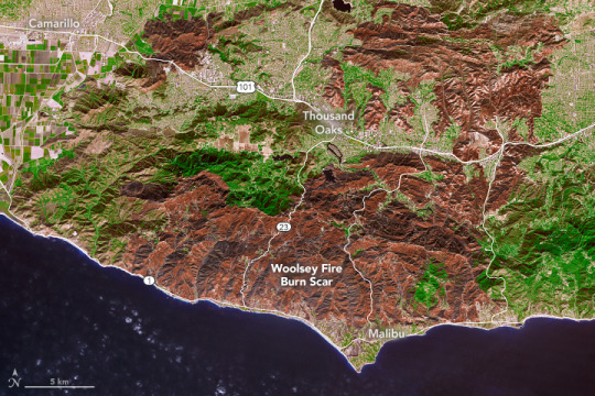
With California wildfires still burning, the
2018 fire season continues to leave its mark on the state’s landscape.
Together, the Camp Fire and Woolsey Fire (as seen above) have burned more than
248,000 acres (1003 square kilometers, or 387 square miles).
Burn scars are what wildfire leaves behind.
With no vegetation to hold the land in place, many burned locations are
susceptible to landslides and mudslides, especially in areas with steep slopes.
Fighting fires on these slopes is more difficult, too — once a slope’s
steepness exceeds 30 percent, firefighting with bulldozers or trucks becomes
dangerous, and emergency response teams must fight the fires on foot.
For the past two weeks, our scientists have
been working every day producing maps and damage assessments that can help
agency fire managers understand the active wildfire and plan for recovery. By
deploying research aircraft carrying instruments, like the Uninhabited Aerial
Vehicle Synthetic Aperture Radar (UAVSAR), scientists can identify burned areas
at risk of mudslides in advance of winter rains expected in the area.
Learn more about how we’re mobilizing to aid California fire response here.
Make sure to follow us on Tumblr for your regular dose of space: http://nasa.tumblr.com


Комментариев нет:
Отправить комментарий