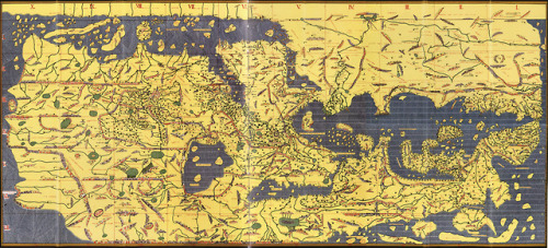
A French copy of Muhammad al-Idrisi’s 12th century map of the known world. Oriented with south on the top, the map was made as part of an atlas for Roger II of Sicily and projected a far more accurate circumference of the earth (22,000 miles) than Columbus did. The book took 15 years to produce.
Космический трэк пространственных событий Тайны Мира, НЛО пришельцы, наука, космос, древние, мегалиты, археология.
Search This Blog
пятница, 12 апреля 2019 г.
worldhistoryfacts: A French copy of Muhammad al-Idrisi’s 12th…
Подписаться на:
Комментарии к сообщению (Atom)
Popular last month
-
A human journey to Mars, at first glance, offers an inexhaustible amount of complexities. To bring a mission to the Red Planet from ficti...
-
Надпись на берестяной грамоте 11 века, найденной в Новгороде (приб.-фин., на кириллице): юмолануолиінимижи ноулисъхянолиомобоу юмоласоудьни...
-
Sri Ashta-Lakshmi stotra is an appeal to the eight subordinate manifestations of Lakshmi and as the beloved of Madhusudana (Lord Krishna), ...
-
Ади Лакшми или Маха Лакшми («Первая/ Первобытная Лакшми» или «Великая Лакшми») – высшая богиня мать, и поэтому она также известна как Ади ...
-
The quadruplet spacecraft of the Magnetospheric Multiscale mission have just returned from their first adventure into the solar wind — saili...
-
Image of the Week – October 21, 2019 CIL:48108 — http://cellimagelibrary.org/images/48108 Description : Differentiated rat neural stem c...
-
Caerleon Roman Amphitheatre, Caerleon, South Wales, 31.12.18. Source link
-
Thanks to the recent release of the Mathieson et al. 2018 dataset (see here ), I’ve been able to spot a very interesting northwest to southe...
-
Полет над кратером проснувшегося вулкана Симмоэ (Япония, 11.10.2017)
Комментариев нет:
Отправить комментарий