It won’t be until summertime that a significant amount of melt shows up across the Greenland Ice Sheet. For now, most indications of meltwater ponds and lakes are leftovers from past seasons that have since refrozen.
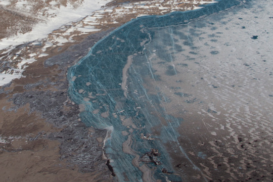
These photographs were snapped during research flights for NASA’s Operation IceBridge—now in its final year after a decade of airborne missions to map polar ice.
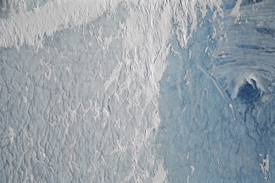
This second image was acquired on April 18, 2019, with the Continuous Airborne Mapping by Optical Translator (CAMBOT) system. The system takes downward-looking images throughout a flight, which can later be used by scientists to interpret other data. This image shows part of a large, frozen lake on Storstrømmen Glacier. This lake also thaws in summertime, which is why it shows up as blue ice.
Lakes atop a glacier, or “supraglacial lakes,” are somewhat stable in terms of their location, according to Joe MacGregor, NASA project scientist for Operation IceBridge. The lake on Storstrømmen is visible in satellite data at least as far back as May 2012. On occasion, water in lakes like this can drain away through a vertical shaft known as a “moulin.” Scientists initially wondered if the dark circular area on the right side of this image could be a moulin, but closer inspection suggested it is just a deeper part of the lake.
See more photos of the frozen lakes in Greenland: https://earthobservatory.nasa.gov/images/144965/greenland-refrozen
Make sure to follow us on Tumblr for your regular dose of space: http://nasa.tumblr.com.


Комментариев нет:
Отправить комментарий