Image Credit: Department of Transportation. U.S. Coast Guard. Office of Public and International Affairs
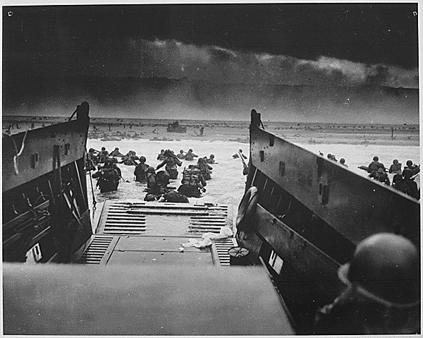
It was the raw courage of the more than 160,000 Allied troops who stormed an 80-kilometer (50-mile) stretch of heavily fortified beaches in Normandy, France, that made victory on D-Day possible. But without the sound advice of meteorologists and geologists working behind the scenes, one of the most consequential battles in human history could have gone quite differently.
As D-Day neared, the American meteorologists predicted fair weather on June 5 and pushed for invasion, based on a forecasting method that gave great weight to historical weather conditions for a given date and location. The British forecasters took a different approach, focusing instead on analyzing measurements of temperature, pressure, and humidity to try to map out weather fronts. Unlike the Americans, the British teams predicted low clouds and stormy weather on June 5. At the last minute, Captain James Martin Stagg, the highest ranking of the meteorologists, convinced Eisenhower to postpone the invasion.
NASA Earth Observatory images by Joshua Stevens, using Landsat data from the U.S. Geological Survey
Meanwhile, on the other side of the English Channel, German meteorologists had come to the same conclusion—and then some. Their forecasters had predicted that gale-force winds would arrive on June 5 and persist until mid-June. The Germans were so confident that the Allies would not dare attack that they allowed many soldiers to leave their posts on the beaches and take part in war games in Rennes, France. Field Marshal Erwin Rommel felt comfortable enough to return to Germany to deliver a pair of shoes to his wife as a birthday present.
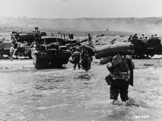
Image Credit: Department of Defense. Department of the Army. Office of the Deputy Chief of Staff for Operations. U.S. Army Audiovisual Center. ca. 1974-5/15/1984
When the first paratroopers were dropped behind enemy lines around midnight and the first wave of Allied boats began to swarm the beaches at dawn on June 6, the weather was still far from ideal. Cloud cover meant many paratroopers ended up in the wrong locations, and rough seas and high winds made the task of landing boats and unloading tanks a terrible challenge. But by noon the skies cleared, just as the Allied meteorologists had predicted. The Germans, meanwhile, had been caught off guard. That day the Allies endured thousands of causalities, but they established a toehold in France that they would never give up.

NASA Earth Observatory images by Joshua Stevens, using Landsat data from the U.S. Geological Survey
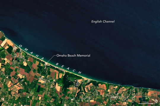
An enormous amount of scientific expertise went into even the most unscientific of tasks, like rolling a tank up the Normandy beaches. Prior to the invasion, Allied military planners studied nearly one million aerial photographs of the shores of Normandy to find the best landing sites. The aerial photographs would have looked something like the Landsat 8 images shown above. Acquired by the Operational Land Imager (OLI) on July 15, 2018, these image offer a top-down view of the sandy Normandy beaches that were center stage on D-Day.
Read the full story: https://earthobservatory.nasa.gov/images/145143/forecasting-d-day
Make sure to follow us on Tumblr for your regular dose of space: http://nasa.tumblr.com.


Комментариев нет:
Отправить комментарий